Friday, October 28, 2011

Snow on the Pumpkins

The first snow of the season fell last night. Big, heavy, wet flakes started coming down after dark as the temperature started to slide toward 32F. The temperature slipped a bit below the freezing mark overnight; our first frost, but it wasn't a hard frost.


The pumpkins await carving this weekend in advance of Halloween trick-or-treating, which in our town is Sunday evening - Halloween Eve.

Tuesday, October 25, 2011

Evans Notch Continued

Here is part two of our weekend of hiking in Evans Notch.

For Saturday we chose a loop trail from our Cold River Camp cabin to Eagle Crag, which lies just north of North Baldface Mountain. The 0.7 miles to the first trail junction near the Emerald Pool was easy walking; by then we'd met several other hiking parties heading in the same general direction. At this juncture the hike to Eagle Crag required a water crossing, a crossing that looked a little tenuous so we changed our plans.

We opted instead to take the Baldface Circle Trail to South Baldface Mountain; this required no major river crossings but did have steep ledges up high. The sky above was gray, while the canopy just above our heads was lit up like a bonfire by beech and other hardwoods in their fall colors.


But alas, a long hike was not in the cards on Saturday. We reached only to the South Baldface shelter, just in time for lunch and just as it started to rain. Many other hikers arrived at the same time, the shelter got a little crowded. We chatted about trail conditions, the steep, upper ledges we were told were quite slick. We made one attempt at the ledges, but changed our plans and headed back the way we came. On the descent we took in the 1/2 mile loop to Chandler Gorge, a worthy side trip from the Baldface Circle Trail.

Despite the twists and turns in our hike on Saturday, the woods were beautiful and the hike as always was rejuvenating. The leaf-covered trail was dotted with fresh raindrops as we turned back toward camp.


Sunday dawned bright, as we observed from Little Deer and Deer Hill and as noted in my post yesterday. Despite a snafu in the morning schedule between us and our friends (Srini, Kodi, and I lingered too long soaking up the sunrise on the Deer Hills!), the four of us (plus Kodi) rallied in late morning for a second Sunday hike. We drove north on Route 113 to the height of land in Evans Notch, a stunning drive in late fall. Our destination -- not to be deterred this time -- was the 3,210-foot West Royce.

By the time we got underway on the East Royce Trail at 10:00 am, the sky had turned a steel gray. No wind stirred, not the slightest breeze. The hike from the parking lot to the top of West Royce was a steady, steep climb from the start. The trail crossed several small streams with cascading falls and climbed through a beech and birch forest.


As we climbed above 2,000 feet in elevation, the trail entered a beautiful spruce forest with lots of little spruces coming up, a soft bed of fallen needles on the trail, and moss and lichens covering large boulders.


Around 2,600 feet a spur trail led to the right up to the peak of East Royce Mountain. We skipped this side trip, continuing on instead to West Royce. The next one mile or so was relatively flat, even dipping down a bit into a mossy, muddy, moosey kind of place. We saw a nice set of fresh moose tracks in the trail. An AMC trail crew did some amazing recent work on the trail, cutting, sawing and placing bog bridges through a wet, muddy stretch that must have taken a beating from Hurricane Irene.


The Royce Trail passed through a hobblebush clearing - the short shrubs were browsed heavily by moose -- before reaching the juncture with the Burnt Mill Brook Trail. This latter trail descends into the Wild River drainage - a wild looking trail if ever there was one. The birch growing in this strange spot were gnarly, the rocks were covered in ferns and moss, and the trail was one long mud hole with small, unruly boulders for stepping stones. It had a Middle Earth sort of feel to it.

Moose-browsed hobblebush and gnarly birch on the Royce Trail
between West Royce and East Royce


A crooked sign pointed the way down into the wilds of the Wild River drainage


From here were started up the final 0.7 miles to the top of West Royce. The narrow path snaked its way up through a dark and dense and moist and mossy spruce-fir forest. I brought up the rear, stopping to chat with two friendly boreal chickadees.


The views from the top of West Royce were not spectacular, though the climb to get there was intriguing. We stopped on one of the ledges for lunch, gazing down on Route 113 nestled in the hardwoods below. The gray skies seemed darker, the temperature decidedly cooler.


Clothed in our fleece jackets, hats, and gloves we began our descent, leaving behind the fir and spruce atop the Baldface Royce Range.


Monday, October 24, 2011

Evans Notch

Route 113 winds its way up through Evans Notch on the eastern side of the White Mountain National Forest. The windy, scenic road begins in the broad floodplain of the Saco River in Fryeburg, Maine. By the time you reach the Notch you've crossed back and forth between Maine and New Hampshire a few times. We spent the weekend hiking this region, staying at the Appalachian Mountain Club's Cold River Camp. The Camp is bustling with visitors and staff in summer, but in the off-season only one cabin is available for overnight stays. Our friends Dale and Lisa snagged a 2-night booking for the four us, a terrific "base camp" for two days of nearby hiking.

The weekend weather was not terribly cooperative, yet we squeezed in some superb hiking on woodland trails cloaked in golden yellow leaves and through spruce forests draped in moss. Our destinations took us to some fabulous views. My motto though was to not miss the forest for the views. The woods and rocks and waterfalls were just as inspiring as the views.

One of the sweetest hikes was a Sunday morning sunrise hike to the diminutive Little Deer Hill and Deer Hill in Maine. We reached these 1,000-footers from our cabin at Cold River. A camp trail leads down to the river then crosses to the other side via a dam built in the 1960s. This same spot can be reached from the Baldface Circle parking lot taking the Deer Hill Connector. We actually hiked to Little Deer twice - Friday night just at sunset and then again Sunday morning. Kodi made the crossing fine on Friday, but needed a lift across the middle part on Sunday.


Just after you cross the Cold River you reach the state line.


The hike to the Deer Hills was a 3.5 to 4 mile hike up and down and around wooded slopes with some ledges near the top. We reached the top of Little Deer Hill after a 30 minute hike from the cabin - just at sunrise. the Baldface Royce Range to our west was bathed in morning light. The valley below was cloaked in morning fog. South Baldface stands out with its broad, bald face.


Kodi sat on Little Deer Hill taking in the sunrise.


As the fog began to lift in the valley below, we headed to Deer Hill.


The 0.7 mile trail over to Deer Hill is first down then back up. The top of Deer Hill (1,327') is wooded with little view. Continuing on the Deer Hills Trail another 100 feet leads to a lower ledge and a fabulous view. We sat looking east absorbing the warmth of the morning sun as it rose over Palmer and Adams Mountains. The entire length of Kezar Lake was hidden by fog.


The Chatham Trails Association maintains 40 miles of trails in this region. From our experience on this little hike they do excellent work, keeping trails open and maintaining nice trail signs. Thank you CTA.


The oak forest on the east and south slopes of Deer Hill is beautiful, the red and black oaks tall and stately and gorgeous in their fall colors. The understory of golden yellow beech leaves lit up the forest, something we experienced all weekend.


Our loop hike brought us back to Little Deer Hill, before we descended back to camp. By this time of the morning the fog had cleared and the Baldface Royce Range looked bright and welcoming. The bluish sky promised a good day of hiking, but alas the clouds returned. More tomorrow on our weekend of hiking, including our Saturday attempt at Eagle Crag and a second hike on Sunday to West Royce.

Until then, here is the Baldface Royce Range again on Sunday morning before we descended to camp. Sometimes the smallest hills give you the best views.

South Baldface Mtn and North Baldface Mtn from Little Deer Hill


Mt. Meader from Little Deer Hill


The Basin from Little Deer Hill.


Thursday, October 20, 2011

Peeling Potatoes

Sitting on the front stoop peeling potatoes on a Thursday afternoon in mid-October.  The clouds are shifting and blue sky is emerging. The air is still damp after two days of rain. Kodi sniffs the air.


Kodi likes to be outside so I am outside too, to keep an eye on him. He likes to wander. The fresh breeze feels nice on my face. A pair of pileated woodpeckers works the top of a dead black cherry nearby. They don't seem to mind us so close. They are having a meal, while I prepare a meal for later.


The hazelnut bush in our yard to my right is in full fall color. A few peepers call from trees in the backyard. I wonder why they peep now, not a chorus from the wetland as during breeding season in spring, but soft isolated peeping. I look at the vegetable garden and wonder about the painted turtle eggs that were laid back in June. The hatchlings have yet to emerge; sometimes they overwinter in their nest. That seems like a long time to wait.

Kodi is on the move, he caught a whiff of something. No doubt he's headed to the woods in the back, where wild animals wander at night. Perhaps he smells the fox that calls from the woods many nights or the pack of 3 or more coyotes that howled and yipped all night long two nights ago. I assume it is a fellow canine that intrigues him or unnerves him or just makes him curious.

The potatoes are peeled and the woodpeckers have moved off to another tree, I hear one call to the other. Kodi, quiet as a mouse, is nosing about a tree stump in the woods. I call him in for his dinner. The potatoes await my next move.

Wednesday, October 19, 2011

Fall Turns A Corner

Today feels like the transition to late fall from early fall. Still no frost (amazingly), but the weather has turned a corner I think. Today is gray and rainy and many leaves are falling from the trees. There is an inkling of cooler temperatures to come.

As Kodi and I took our morning walkabout, I noticed more hardwood trees empty of all leaves. Although the leaves have dropped, the beauty of the bare tree -- twigs and branches and limbs and trunk -- is fully exposed. I can see the shape of the tree better. And I can see farther into and through the woods. So although the skies grow gray and the days shorten, there is a lightness in the forest as trees release a season's worth of leaves back to the soil.

Another fall ritual that I noted today is the drawdown of lakes and some rivers for the winter, to allow room for spring floods to fill the water levels back up. Perhaps the river that Kodi and I walked along today was for another purpose. Regardless, the gray, gooey stream bottom was now exposed, adding to the grayness of the day.


Kodi checked out the new shoreline. I'm sure the soft mud felt different between his toes as he raced back to the trail and twirled around a few times. He is carefree in all seasons; gray sky, blue sky, wind, rain, sun, snow makes little difference to Kodi as long as he is out in the elements. Watching Kodi frolic in all types of weather, makes me happy to be out and about too, gray days and all.

Tuesday, October 18, 2011

A Management Challenge

Yesterday I spent a lot of time surrounded by tall, scraggly, dense shrubs. I was mapping trails and habitats on a large, flat, wet property.  Past land uses have taken a toll on the site. Woods roads and trails were used and abused by off-road vehicles of all sorts. The exceedingly flat topography, unusual amount of rain this year, and the severe erosion has created a drainage nightmare.

This is supposed to be a walking trail.


The land was conserved this year and I am writing a stewardship plan to guide management and public uses. The first task is to figure out the re-arranged hydrology and drainage and block the continued illegal use of trails by off-road vehicles. I found four sofas dumped at various places, dozens of tires tossed here and there, a few mattresses, and miscellaneous trash.

I tried walking the trails wearing my knee high rubber boots. The water in many places was at least a foot deep and in some places over my boots. This forced me off trail into the woods and shrub thickets. I crouched and crawled and groaned my way through the dense undergrowth. Generally I would appreciate the shrubs surrounding me - highbush blueberry, winterberry, witchhazel, sweet pepperbush, mountain holly. But, after 7 hours I was spent.

The good news for the day was the weather - a beautiful blue sky, light breeze, and moderate temperature. By late afternoon the setting sun was brilliant among the overhead shrubs and trees, highlighting the yellows, reds, and browns of changing leaves. As I waded down the last trail back toward the car I was enchanted by the fallen sassafras leaves floating in the water. This small tree has leaves with three shapes: entire (no lobes), mitten-shaped, and three-lobed. Mostly I saw the three-lobed type.


The floating sassafras leaves distracted me for a time from thinking about the management options on this property. The watery trail though forced me back to considering the challenges ahead. As with many such management challenges, it involves correcting mistakes and misuse by humans.

One other bright spot for the day was walking into a fen (a type of peatland) on the property. This natural community was wet, it was supposed to be.

Saturday, October 15, 2011

Black Birch

The birches are understated in their yellow fall colors, amidst the generally brilliant reds and oranges of the maples. This year, however, I am taking more notice of the birches as the sugar maples have succumbed to fungal diseases from wet weather in spring and again in fall. All the birches that grow here -- yellow, black, gray, and paper -- turn a soft shade of yellow.

Black birch (Betula lenta) is more common in our woods than you might expect, especially here in southern New Hampshire and parts south. It seems to grow most abundantly on moist, protected northerly or easterly slopes, although it appears on dry, rocky sites too. I see it growing commonly among red oak and white pine. Last week Kodi and I hiked along a local trail, where the black birch saplings were lit up by the midday sun.


Up close the egg-shaped black birch leaves are distinct with sharply toothed edges and a heart-shaped base.


Crush the leaves or break a branch or chew on a twig and a wonderful wintergreen aroma wafts up. The oil of wintergreen is found in the inner bark -- once the only source of wintergreen oil, which is now made synthetically. The wintergreen aroma and taste is the reason it is known by another name: sweet birch.


The bark of the tree is distinct when the tree is young -- relatively smooth, dark gray, with horizontal lenticels. As the tree matures it takes on a much rougher look. Here is the trunk of a young black birch.


The cones bear tiny winged seeds that disperse by wind in the fall.


Black birch being at the northern edge of its range in these parts, seems to have adapted well to past changes and may do well as the climate changes. Black birch has filled in some of the "holes" in the forest that American chestnut once filled before it was decimated by the chestnut blight. Where gypsy moths have knocked back oaks and where hemlock woolly adelgid has killed hemlocks, black birch has moved in.

With its attractive fall colors, sweet wintergreen aroma, strong wood - it takes on a dark shade similar to mahogany, and adaptability, black birch is quite a tree.

Wednesday, October 12, 2011

Our Country

I rarely delve into politics on this blog. Last February I made an exception and recognized the courage of the Egyptian people to take back their country. Their struggle continues as the powerful try to re-take control of people's lives in that country.

Today seems appropriate for another diversion into politics or perhaps it is just life. Today I celebrate the courage, enthusiasm, and creativity of the Occupy Wall Street crowds springing up around the country. This morning on NPR we learned that the D.C. group is forming a winterizing committee (as they intend to stay as the weather turns cold). How great is that!

I recall that most everyone celebrated the Egyptian people when they took to the streets for peaceful protests. Yet, when Americans do it here, they are quickly condemned. Sounds like the powerful here are a little scared of the people. They should be. Things aren't working, and mostly because of bad decisions by decision-makers over the past 30 years.

My friend Carl has re-connected me with the wise words of Aldo Leopold, a conservationist, forester, author, and more, who died too young way back in 1948. Leopold wrote that "there were two things that interested me: the relationship of people to each other and the relationship of people to the land." To me this is what the protests are about -- how "we" treat each other and how "we" care about the land. As a country, we seem to be failing on both fronts. Leopold must have had a positive outlook on life as he lived and worked during an equally difficult time. With Leopold's wisdom in hand, I will remain optimistic as I pursue my own path connecting people to the land.

Saturday, October 8, 2011

North Moat and The Red Ridge

We packed our hiking gear yesterday morning when the temperature was near freezing, but we packed relatively lightly for an early October day hike in the White Mountains, as the weather forecast was for clear skies and mild temperatures. The day did not disappoint.

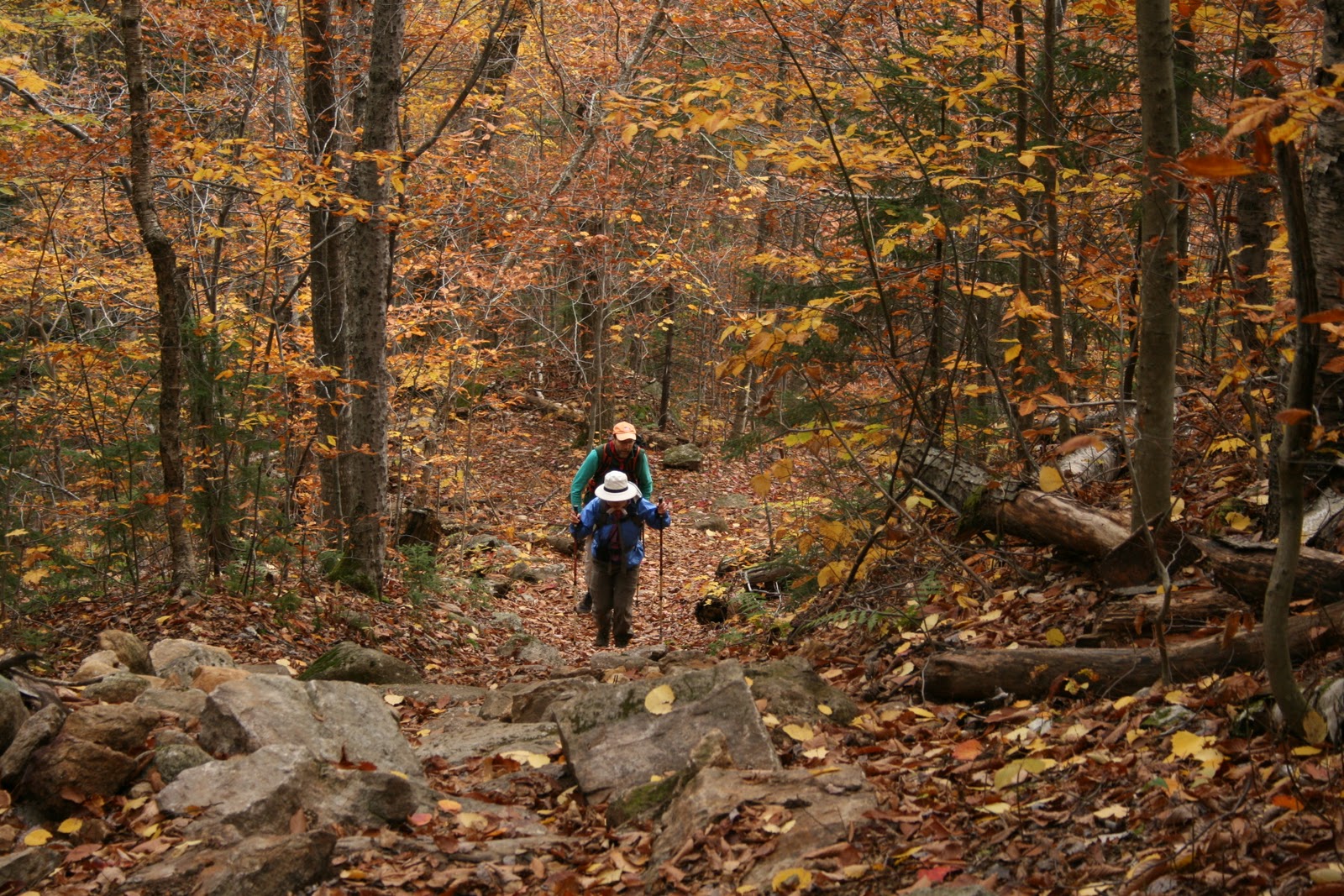
We set off on our 10-mile hike at 9:30 from West Side Road near the Bartlett/Conway town lines at the parking lot for Diana's Baths. Only one other group -- a man and his grandson -- was on the trail. We set off at a brisk pace, stopping briefly at Diana's Baths to admire the falls and pools.


Our route took us along the Moat Mountain Trail, past Diana's Baths and Lucy's Brook, 4.2 miles to the top of the 3,196-foot North Moat. The first 2.3 miles of Moat Mountain Trail are a gradual climb that gives you a chance to work the kinks out of your hiking legs. After about a mile we crossed Lucy's Brook by stepping on stones; the water level low enough to keep our boots dry. Just below the junction with the Attitash Trail we nearly ran into a small black bear. Kodi was ahead and the bear quickly shinnied up a nearby tree. He was small - about the size of our 50 pound Kodi. We didn't see a mother bear but didn't want to linger in case she was nearby. The bear looked at us curiously and started backing down the tree, perhaps wondering if Kodi was a fellow bear cub.


At 2.3 miles the trail turns south (Attitash Trail continues west over to Bear Notch Road) and begins to climb more steeply, passing through a hemlock-red pine-spruce forest.


By this time the air had warmed to the 40s and with the steeper climb we shed our hat, gloves, and fleece jacket. And Kodi was looking back wondering why the slower pace.


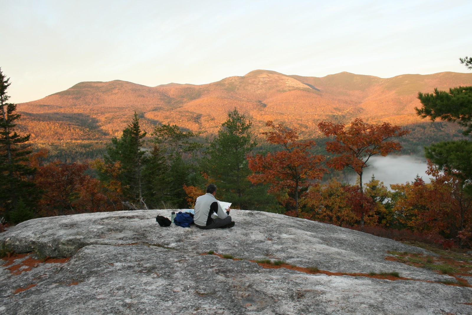
As we climbed we started to look back through the trees, catching views to the north. Our first great view was of Carter Notch off in the distance.


Then we reached a large exposed slab, a perfect place for a snack before the final assault on the summit. 


Just beyond this point we met a man named Glen descending. We heard him first as he was wearing a bear bell. After we told him about the bear cub he gave us the bell, saying he had more in his car. We used it on Kodi for awhile, but it was a little too noisy for me. I like the quiet solitude of the mountain air, listening to the soft chips of little birds and the whisper of the wind in the trees. Still, it was a nice gift and we will use it when in thick bear territory.

We reached the summit of North Moat about 12:30, hungry for our sandwiches. For a few minutes we had the peak, with its 360 degree views, all to ourselves. One couple joined us; they sat quietly enjoying the views too. We needed our fleece, hats, and gloves just to be comfortable. The views were great......

Mt. Washington and the other high summits in the distance.


In another direction Crawford Notch


The mix of dark green softwoods and brilliant hardwoods
offered beautiful contrasts on the slopes.


And a look south to Middle Moat - the bald one in the distance.


We began our descent about 1:15, continuing south on the Moat Mountain Trail for 1.1 miles to the junction with the Red Ridge Trail. This leg drops steeply through a series of wooded ledges; the trail followed along the base of one such massive ledge.


This leg of the trail is also very narrow, with some logs across the path and small spruce saplings and hardwood shrubs overtaking the trail a bit. It could use some brush back. It got us thinking that we really should adopt a trail.

We reached the trail juncture and took one more look back at North Moat with Mt. Washington still visible off its right shoulder in the far distance.


As it names suggests, the Red Ridge Trail follows a ridge, mostly bare and exposed. All of the Moats and much of the ridge are bare, apparently from fires some time ago. The red perhaps is from the color of the rock, but others might correct me there. The rock was more pinkish than red.


The exposed ridge offered great views all the way down and tucked into pockets among the rocks were alpine plants that had turned shades of red and purple.


Below treeline a small wetland was full of cotton-grass, a beautiful sedge that forms cottony heads.


The Moats are also known for the red pine that grows on the drier slopes. It has scaly red bark and often has interesting form.


The trail crosses Moat Brook -- more stone stepping -- and then follows the shoreline before turning and crossing an active Forest Service Road. The rest of the trail is a bit of a slog back to Moat Mountain Trail, although it passes through a beautiful northern hardwood forest with huge yellow birch and white ash. This section of trail was also quite wet and muddy. We reached the car just before 5:00, about 7 1/2 hours after our start.

This was our first time on these trails and we loved it. The 10-mile loop was strenuous but I don't think it was difficult. The bear was a treat and the trails pass through a wonderful diversity of plant communities. It could use a little care in terms of blazes and trail clearing.

Just before reaching Diana's Baths on the return we stopped to admire a tree covered in mushrooms. It was dark in the hemlock woods along the brook but still bright when we emerged into the parking lot after a fine day of hiking.


First Walks of 2024

We rise early, well before sunrise. It helps to go to bed early. Fortunately the New Year's Eve celebratory fireworks in the neighborhoo...